PROJECT TASKS
Stream Visual Assessment
The Stream Visual Assessment Protocol (SVAP) developed by the Natural Resource Conservation Service of the U.S. Department of Agriculture was used to assess the health of the stream, identify pollutant sources, and identify potential management measures to control these pollutant sources based on visual inspection of the physical and biological characteristics of instream and riparian environments of the assessed stream reaches. The assessment is based on a three-page worksheet modified for New Jersey by the Rutgers Cooperative Extension Water Resource Program. The SVAP assesses a set of 15 stream condition indicators and assign each indicator a numerical score relative to reference conditions. The specific indicators include channel condition, hydrologic alteration, riparian zone, bank stability, water appearance, nutrient enrichment, barriers to fish movement, instream fish cover, pools, insect/invertebrate habitat, canopy cover, manure presence, riffle embeddedness, and macroinvertebrates observed if applicable. The score for each element is assessed on a scale of 1 to 10, with one being the worst and ten being the best. The scores of the 15 elements at each site are averaged to give an overall rating for that assessed stream reach. A score of less than 6.0 is considered “Poor”, a score of 6.0 to 7.49 is considered “Fair”, and a score above 7.5 is considered “Good”. The numerical assessment is complemented by photographs and drawings of the stream site, as well as notes on visual observations of unusual or unsightly occurrences such as dumping, manure, runoff or outfall pipes, etc.
Progress and Status
- About ten local volunteers were recruited by South Branch Watershed Association to conduct the SVAP in the project area.
- On March 16, 2007, project team members and some volunteers participated in the SVAP training held by Rutgers University.
- On May 5, 2007, New Jersey Water Supply Authority will hold an additional SVAP training for the project team members and volunteers who will conduct the SVAP for the project.
- All stream-road crossings in the project area were evaluated and about 60 stream reaches at the crossings were identified as potential candidates for SVAP.
- SVAP was performed on 42 stream reaches by team members and volunteers during the period of July-October, 2007.
Results and Outcomes
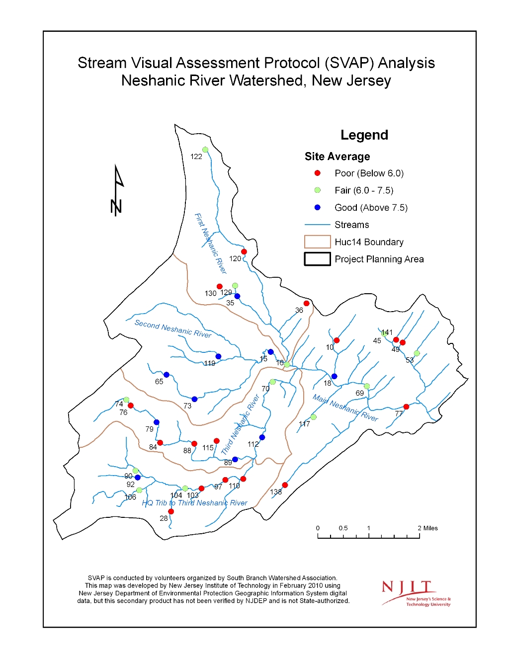
Of the 42 stream reach sites which were assessed, 18 scored “poor,” 13 scored “fair,” and 11 scored “good.” Of the five HUC-14 subwatersheds in the project area, HQ Tributary recorded 3 fair and 4 poor sites; The Third Neshanic had 3 good, 2 fair and 5 poor sites; The Second Neshanic had 5 good and 1 fair sites; the First Neshanic had 1 good, 3 fair and 3 poor sites; and the Main Neshanic had 1 good, 4 fair and 6 poor sites.
The good sites, when compared to the poor and fair sites, have higher ratings for riparian zones, bank stability, channel condition, pools, in-stream fish cover, canopy cover and invertebrate habitat. Many of the “poor” sites have a stream bed of sand/silt/mud or gravel, while the “fair” and “good” sites are gravel/cobble/boulder. The “poor” sites often score much lower on pools, channel condition, in-stream fish cover, canopy cover, and invertebrate habitat than the “good” sites. Many sites had similar issues degrading stream quality and riparian conditions. Observations common to many of the sites include erosion, dry stream and low flow in summer, occasional dumping, exposed drainage pipes, and overgrowing invasive plants.
Improving riparian zones and bank stability at the poor and fair sites will, over time, lead to better ratings for many of the other indicators observed in the SVAP assessment. The possible recommended remedies may include riparian plantings; added or expanded riparian buffers; bank stabilization; reconnection to flood plain; and removal of invasive plants.
For details, please read:
- SVAP Technical Report
- SVAP Maps [pdf]
- SVAP Maps [zip]
- SVAP Field Notes